

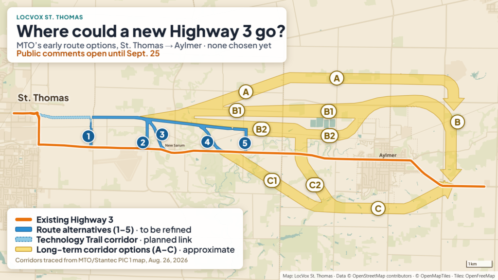
The Ministry of Transportation has posted its first look, for this new study, at how it might build a stretch of Highway 3 east of St. Thomas, an early step that could reshape farmland between the city and Aylmer for decades to come.
MTO has studied this stretch of Highway 3 since 1975 and still has a route designated from back then. A 2021 feasibility study recommended a fresh look at both the designation and the route, leading to the current study. MTO hired Stantec Consulting to run it, called a Planning, Preliminary Design and Class Environmental Assessment. The first public meeting for this round was Wednesday, August 26, at the East Elgin Community Complex in Aylmer, and the presentation boards went up on the project’s own website the same day.
Why now
The study’s own traffic numbers explain the timing. Right now, Highway 3 handles its traffic well, with only moderate delays at Centennial Road during the afternoon rush. MTO modelled two futures. If traffic keeps growing the way it has, the road mostly keeps up, with just that one intersection getting busier. But the wider Highway 3 corridor area, which MTO’s growth maps stretch from St. Thomas past Aylmer to Tillsonburg, is forecast to add 60,100 people and 32,250 jobs between 2021 and 2051, using long-term forecasts prepared by the City of St. Thomas, Elgin County and Oxford County. Much of that growth is tied to St. Thomas, especially the new PowerCo battery plant, expected to employ 3,000 people directly and support up to 14,000 more jobs regionally once fully running. If that growth happens, MTO’s modelling says Highway 3 would be over capacity by 2051, the Centennial Road intersection would be over capacity in both the morning and afternoon rush, and some traffic would likely shift onto local roads.
What MTO looked at, and ruled out
Before landing on a new highway corridor, the study screened four other options: doing nothing, managing travel demand with technology and policy, expanding transit and rail service, and simply widening the existing road network. MTO’s own evaluation says none of those fully solves the capacity problem on its own, though improving local transit and widening some existing roads will still be considered alongside the main plan. The only option carried forward for detailed study is a new Highway 3 corridor connecting to the Technology Trail, the eastward extension of the St. Thomas Expressway.
Where a new route could go
The map MTO showed at the meeting draws the options in two layers. Closest to St. Thomas, a set of five numbered route alternatives runs in a defined line just north of the existing highway, from the Technology Trail at Yarmouth Centre Road east to Penhale Road, with numbered segments linking that line back down to today’s Highway 3 at several points along the way. These are the most specific pieces on the map, though MTO says even they will be refined and adjusted as the study goes on.
East of there, the picture widens. What MTO labels its long-term corridor alternatives are broad, approximate bands rather than drawn routes, and they run on both sides of the existing highway, not just one. Some stay north and pass above Aylmer; others cross the highway and loop below the town to its south; all of them rejoin Highway 3 well east of Aylmer. MTO is careful to say these are early, rough corridors, not a chosen route. They will be narrowed and refined as the study continues, weighing factors like traffic performance, construction cost, and impacts on farmland, wildlife and water. The area includes stretches of Catfish Creek and its wetlands, which the study’s own environmental mapping flags as a constraint the route will need to work around.
What it means for landowners
MTO says any private property actually needed for the route it eventually chooses will be bought at an independent market appraisal, with a real estate officer to walk owners through the process. Separately, and regardless of how the study turns out, work close to MTO’s existing highway land already needs the ministry’s sign-off: within 45 metres of the highway property, within 395 metres of an intersection, or within 800 metres if the work could have a big effect on traffic.
What’s next
MTO wants public comments by September 25, either through the project’s own website, by email, or by phone to the project team. A second public meeting will present a narrowed list of route options along with early design details, followed by a 30-day public comment period on a formal Study Design Report. Elgin County council, briefed on the study August 11, was told the study and its environmental clearance are currently expected in spring 2028.
This is a separate project from the two other pieces of Highway 3 work already underway: the twinning project tied to the PowerCo plant, and the August resurfacing between St. Thomas and Aylmer. Both of those work with the highway as it exists today. This study is asking a longer question: whether St. Thomas and Aylmer need a different highway altogether.
Sources: MTO/Stantec: Highway 3 Planning Study, Public Information Centre 1 presentation, Elgin County: From the Council Chambers, August 11, 2026, Project website: highway3elgineast.ca
By Anthony Zruna · About the LocVox Newsroom
Update - August 27, 2026, 9:17 a.m. ET: Clarified which area the population and job growth figures cover: the 60,100 people and 32,250 jobs are forecast across the wider Highway 3 corridor area, stretching from St. Thomas through Aylmer to Tillsonburg, between 2021 and 2051.

Before you go
You read a local story to the end, so St. Thomas news matters to you. Once a week I gather the whole week into one Friday email: top stories, the weekend forecast, what council decided, what police logged, and what's on this weekend. Free, and one click unsubscribes you.
Send me Friday's newsletter